
Video: Freezing rain, ice accumulation Monday in New Hampshire
WAS HURT. ALL RIGHT. NO TORNADOES THIS WAY, BUT CERTAINLY DANGEROUS CONDITIONS. YEAH, AND IT’S ALL FROM THE SAME EXACT SYSTEM, ACTUALLY, THAT’S COMING THROUGH. AND SO WE’RE GETTING THE MILDER AIR FROM THAT SYSTEM. BUT AT THE GROUND, THAT’S THE PROBLEM. WE’RE AT FREEZING OR EVEN BELOW FREEZING. SO THAT’S WHY YOU GET THE LIQUID RAIN THAT COMES DOWN AND THEN FREEZES ON CONTACT. IT’S A BIG SYSTEM. YOU CAN SEE THE TRAILING COLD FRONT ALL THE WAY DOWN THROUGH THE OHIO RIVER VALLEY. THAT’S WHERE THE SEVERE STORMS HAVE BEEN WITH THIS SYSTEM TODAY. WE’VE GOT THE ICE AND THEN EVENTUALLY CHANGING OVER TO PLAIN RAIN IN FAR SOUTHERN NEW HAMPSHIRE BY LATER ON THIS MORNING. SO THERE SHOULD BE SOME RAPID IMPROVEMENTS IN THE ROAD CONDITIONS, AT LEAST FROM MANCHESTER, DOWN INTO, SAY, SALEM, NASHUA, PORTSMOUTH WITHIN THE NEXT FEW HOURS HERE. BUT IN CENTRAL NORTHERN NEW HAMPSHIRE, WESTERN AREAS CLOSER TO THE UPPER VALLEY, WE COULD SEE A PROLONGED PERIOD HERE OF FREEZING RAIN. THEN FOLLOWING BEHIND THIS SYSTEM, IT TURNS ABSOLUTELY BITTER COLD. OUR HIGH TEMPERATURES TOMORROW WILL STRUGGLE TO GET OUT OF THE TEENS, AND THE WINDS MAY BE A BIG FACTOR TOO. IN FACT, OVERNIGHT AND EARLY ON TUESDAY, THE WINDS COULD GUST UPWARDS OF 40MPH. AND THINK OF THIS IF WE HAVE A WEIGHTED DOWN TREE LIMBS AND POWER LINES DUE TO THE ICE, AND YOU GET STRONG WINDS BEHIND IT, THERE COULD BE SOME ADDITIONAL POWER OUTAGES BECAUSE OF THAT. BY THE TIME WE GET TO WEDNESDAY, THOUGH, TEMPERATURES START TO COME UP A LITTLE BIT INTO THE 20S AND WE’LL FINALLY GET IN TO SEE SOME SUNSHINE. THE WINDS COME DOWN TO JUST A NASTY MIX ALL ACROSS THE STATE RIGHT NOW. SO SOME AREAS SEEING FREEZING RAIN, OTHERS IT IS PLAIN RAIN AND IT’S VERY HARD TO TELL WHEN YOU’RE OUT THERE TRAVELING WHAT’S WHAT. SO BOTTOM LINE IS YOU’LL NEED SOME EXTRA TIME AND BE PREPARED FOR THE FREEZING RAIN. THAT’S WHAT THIS PINK COLOR IS FROM ROCHESTER TO LACONIA AND EVEN SOME BOUTS WHERE IT’S REAL HEAVY AT THE MOMENT THROUGH FRANKLIN, UP INTO BRISTOL. SEEING THOSE DARKER SHADES OF PINK COLOR. THE PROBLEM IS THE TEMPERATURES ARE OH SO CLOSE TO FREEZING. YOU CAN SEE WE’VE GOT 33 CONCORD, MANCHESTER, 34 IN NASHUA, AND WHEN YOU HAVE TEMPERATURES CLOSE TO FREEZING, THAT MEANS THAT THERE COULD BE ANYTHING THAT’S FALLING, COULD FREEZE ON CONTACT. FUTURECAST SHOWS THAT WILL CONTINUE TO SEE THIS ICY MIX THROUGH THE MID-MORNING ABOUT 10 A.M., AND THEN LIKELY SWITCHING OVER TO PLAIN RAIN, BUT HEAVY RAIN DOWN THROUGH MANCHESTER. NASHUA WITH THE MIXING CONTINUING IN THE NORTHERN PART OF THE STATE, BUT SHOULD LESSEN UP BY THE EVENING HOURS. LET’S BRING IN OUR METEOROLOGIST MATT HOENIG AGAIN. HE’S OUT IN THE STORM TRACKER FOR AN UPDATE ON WHAT’S HAPPENING OUT THERE. HI, MATT. HI THERE. HAYLEY. WE ARE HERE ALONG 93 SOUTHBOUND IN HOOKSETT. AT THE REST AREA, YOU CAN SEE TRAFFIC IN FRONT OF US. VERY LIGHT AT THIS HOUR. AS OF 519, BUT DEFINITELY HIGHWAY SPEEDS ARE MUCH SLOWER COMPARED TO WHAT THEY TYPICALLY WOULD BE ON AN EARLY MONDAY MORNING HERE IN LATE DECEMBER. GIVEN THAT WE STILL HAVE SOME RAIN FALLING OUT THERE, WANT TO SHOW YOU THE LIVE DATA NOW FROM THE STORM TRACKER. YOU CAN SEE THE LOCATION THERE ON YOUR SCREEN, KIND OF SURROUNDED BY THIS PINK COLOR. THAT’S THE RADAR INDICATING THAT THERE STILL IS SOME FREEZING RAIN AROUND THIS AREA. THE AIR TEMPERATURE AT 34 DEGREES DOESN’T SEEM ALL THAT BAD, BUT IT’S THE ROAD TEMPERATURE THAT’S IMPORTANT. SITTING VERY CLOSE TO 32. DEFINITELY SOME ICY SLUSH IN SPOTS. YOU JUST HAVE TO BE SO CAREFUL OUT ON THE ROADWAYS NOW AND THROUGH THE NEXT SEVERAL HOURS. 93 ALONG MANCHESTER AND POINTS NORTH IN POOR SHAPE THROUGH ABOUT 10:11 A.M., 101 THROUGH THE MONADNOCK REGION, 89 UP AND DOWN BETWEEN LEBANON AND CONCORD. LIKELY TO SEE SOME TOUGH TRAVEL. ONE AREA ALREADY SEEING IMPROVEMENTS IS THE SEACOAST ALONG ROUTE ONE. NOT ICY, BUT STILL A WET AND SLOW DRIVE INTO WORK EARLY THIS MORNING. LET’S BRING BACK IN HAYLEY FOR A LOOK AT WHEN ALL THIS RAIN WINDS DOWN AND THE WINDS THAT KICK UP BEHIND THE SYSTEM. WE’RE CONCERNED ABOUT MATT AS THE WIND. NOW, AS FAR AS THE ICE AMOUNTS, THERE MAY BE SOME PLACES, LIKE FROM THE SUNAPEE AREA UP INTO THE WHITE MOUNTAINS, THE MOUNT WASHINGTON VALLEY, WITH UP TO A QUARTER, EVEN A HALF INCH OF ICE ACCUMULATION. NOW, AS WE GO THROUGH THE OVERNIGHT HOURS TONIGHT, ALL OF THIS IS GONE. JUST A FEW SCATTERED SNOW SHOWERS IN THE MOUNTAINS TOMORROW, BUT THE BITTER COLD AIR RETURNS COURTESY OF A VERY STRONG WESTERLY WIND TOMORROW. LOOK AT THIS. COULD BE A FEW WIND GUSTS UP OVER 40MPH. AND AGAIN, THAT COULD CAUSE SOME MORE POWER OUTAGES JUST DUE TO THAT STRONG WIND. NOW, AS WE LOOK TOWARD THE NEW YEAR, WE’
Video: Freezing rain, ice accumulation Monday in New Hampshire

Icy travel is expected in many areas this morning. Enough ice may accrete for downed tree limbs and power lines, resulting in power outages in some areas. As the winds pick up Monday night, blustery and frigid weather will follow for Tuesday into the start of 2026.Freezing rain continues for many this morning, with the exception of far southern New Hampshire and areas right near the immediate coast. While it gets above freezing in Keene, Manchester, and Concord by mid-morning, the colder air may linger in higher elevations of the Monadnock Region into central and northern NH. Some areas of central and northern NH may see a quarter to a half inch of ice due to freezing rain, resulting in very slippery travel conditions and scattered power outages.Afternoon temperatures should get above freezing even up north, making for lower travel impacts during the evening commute. Temps will fall below freezing as the evening wears on, so some re-freeze will be possible on any untreated surface.Blustery and frigid with some sun south and flakes north on Tuesday. Temperatures will hover in the teens to lower 20s.Partial sun with scattered flurries and snow showers Wednesday, especially north and west. A snow shower possible New Year’s Eve, then bright and cold New Year’s Day into Friday.
Icy travel is expected in many areas this morning. Enough ice may accrete for downed tree limbs and power lines, resulting in power outages in some areas. As the winds pick up Monday night, blustery and frigid weather will follow for Tuesday into the start of 2026.
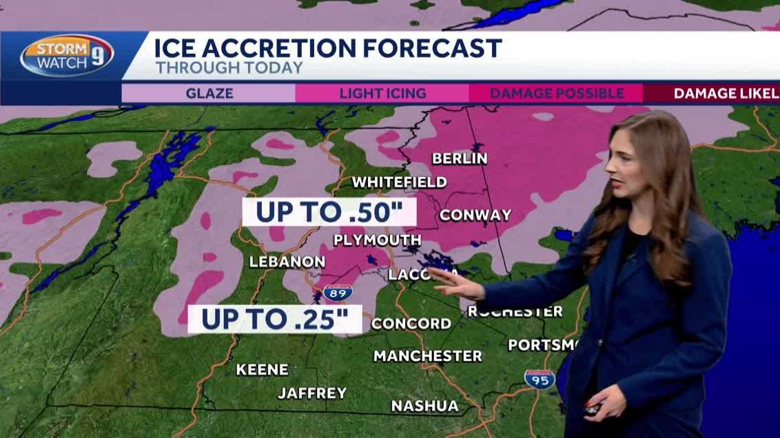
Freezing rain continues for many this morning, with the exception of far southern New Hampshire and areas right near the immediate coast. While it gets above freezing in Keene, Manchester, and Concord by mid-morning, the colder air may linger in higher elevations of the Monadnock Region into central and northern NH. Some areas of central and northern NH may see a quarter to a half inch of ice due to freezing rain, resulting in very slippery travel conditions and scattered power outages.
Afternoon temperatures should get above freezing even up north, making for lower travel impacts during the evening commute. Temps will fall below freezing as the evening wears on, so some re-freeze will be possible on any untreated surface.
Blustery and frigid with some sun south and flakes north on Tuesday. Temperatures will hover in the teens to lower 20s.
Partial sun with scattered flurries and snow showers Wednesday, especially north and west. A snow shower possible New Year’s Eve, then bright and cold New Year’s Day into Friday.